Trip Facts
Trip Code: BTBT-01,
Duration: 13 days,
Program Type: Trekking,
Max. Altitude: 6989m,
Minimum Pax: 2+,
Mode of Travel: Flight/Land,
Start Trip: Paro,
End Trip: Thimpu,
Day by Day Itinerary
Day 1: Arrive Paro
On arrival at Paro airport, received by our representative and transfer to Thimphu. Overnight at the hotel in Thimphu.
Day 2: Paro sightseeing
Day 3: Trek to begin Drugyel Dzong to Shana (17km, 5-6 hours)
First day of the trek follows Paro Chhu valley climbing up the ridges. The actual trek starts from Drukgyel Dzong at 2580 m. From here you look back to see how dzong was positioned. After covering short distance you will find settlement of Chang Zampa. A further walk takes to settlement of Mitshi Zampa finding little shops and hotels.The valley widen and you will reach at army post of Gunyitsawa at 2810 m, there are also primary schools and shops.
Day 4: Shana to Soi-Thangthangka (22km, 6-7 hours)
The trek continuous at side of Pa chhu through conifers and rhododandron coming across Jigme Dorji Wangchuk National Park. By making gentle climb on the rock through oak, crossing several steams come across Phari Dzong of Tibet. Then climb little ridge, cross the Paro Chhu on a wooden bridge. Finally come across Thangthangka at 3630 m, where Bhutanese style house are there.
Day 5: Soi-Thangthangka-Jangothang(Base camp t.Jumolhari,19km, 5-6 hours)
At night Jumolhariis covered with cloud, but be sure to view early in the morning. Jumolhariappears behind the a ridge. Less than an hour from camp at 3730 m is army post. A short climb leads to small chorten finding yak country. Making further climb come across Takethang, clustered of stone houses on plateau at 3940 m.
Day 6: Day halt for altitude acclimatization/excursion
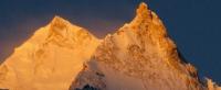
Here is best viewpoint, you won't get better any better than here. The ridge is endless, after an hour of climb you can view Jichu drake (6989 m) and Jumolhari. If you like to see much of the country better to trek Nyile La to Lingzhi.
Day 7: Jangothang to Lingshi(18km, 5-6 hours)
If you have problem with altitude don't go to Lingshi. Ten minutes after beyond the camp, finds settlements. This is the last settlements in the valley and is extremely isolated places. From this place you can also view Jichu Drake. Passing by you can see Jumolharipeak. Then it comes across Nyile La at 4890 m. Dropping down to the valley at 4450 m and stop for lunch here. Trekking further see army camp, where Jumolharipeak is visible. At last coming to Lingzhi.
Day 8: Lingshi to Shodu (22km, 8-9 hours)
The Laya Gasa route leaves the Jumolhari and climbs opposite the camp towards dzong through white chorten. It climbs steeply to Yeli La (4820 m). From this pass on the clear day, you can view Jumolhari, Gangchhenta, Tserim Kang and Masang Gang. Further downstream come across Shodu at 4110 m.
Day 9: Shodu to Barshong (16km 5-6 hours)
The route cross the river 6 times on bridge built of huge logs. Within one hour climb come to Barshong; in Barshong you find small ruin Dzong. The camp in below the ruin dzong at 3680 m.
Day 10: Barshong to Dolam Kencho (15km, 5-6 hours)
The trek continue over dense forest of rhododendron, birch and conifers and drop to Thimphu Chhu. It reach to Dolam Kencho camp at 3430 m
Day 11: Dolam Khencho to Dodina and drive to Thimphu (8km, 3 hours)
The trail goes in and out through conifers and high broadleaf species to pass at 3510 m. The trail drop down and reach to road head at Dodina at 2600 m.
Day 12: Thimphu sightseeing
Day 13: Drive to Paro Airport for departure.